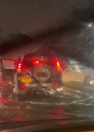
Weekend outbreak: Wild images of flooding as severe storms hit eastern Australia ahead of summer

Wild footage has captured the moment cars became stuck on a main road during flash flooding in Sydney’s south – as the entire east coast braced for ‘very active’ storms.
Taren Point Rd, one of the main arteries leading into the Sutherland Shire, was flooded with water due to heavy rain on Friday evening.
The footage shows several cars getting stuck or stranded along the flooded road as a couple tries to navigate the chaotic traffic.
“I’ve never seen anything like this,” a man can be heard saying in the video.
The footage emerges after severe storms wreaked havoc in NSW, with Australians now warned to ‘remain vigilant’ of flash flooding.
The NSW State Emergency Service (SES) has responded to more than 420 incidents since the storms first began on Thursday, toppling trees, damaging roofs and uprooting fences in Appin and Douglas Park in Sydney’s south-west.
Conditions were so bad that local resident Mary Graham said: “It looked like the cyclones you see in the movies.”
“It’s one of the scariest things you’ve ever seen,” Mrs. Graham said.
“There were branches falling down and hitting different parts of the roof, and I had no idea where we were supposed to be in the house.”


Flash flooding hit Sydney’s Sutherland Shire overnight as the last weekend of spring brings heavy rain

Melbourne, Brisbane, Sydney and Darwin are all set for a wet weekend as bushfires continue to rage on WA’s coast
NSW SES state service commander Acting Assistant Commissioner Paul McQueen on Friday urged residents to “make safe decisions while on the road” amid the potential for flash flooding.
“I urge residents to keep an eye on conditions as we see these storms continuing this weekend,” Mr McQueen said.
‘There is a risk of flash flooding so ensure you make safe decisions along the way and avoid entering flooded roads or roads.
“Please do not drive, play or ride through floodwaters.
‘Stop, turn around and find an alternative route. If you are stuck on a flooded road, call triple-0 immediately.”
Senior meteorologist Dean Narramore from the Bureau of Meteorology said widespread rain, heavy falls and heavy thunderstorms will make Saturday a “very active day”.
Central, eastern and northern Queensland are likely to be hit with heavy rainfall and damaging winds, with the possibility of severe thunderstorms. Some parts of the state’s southeast will also be affected.
Brisbane is expected to reach a high of 27 degrees Celsius this weekend, while NSW will be lashed by thunderstorms.
“(It’s) a very active day across NSW,” Mr Narramore said.

Australians are being warned to be prepared for flash flooding as rain drenches the east coast

NSW SES said they responded to 420 incidents overnight, including fallen trees and power lines
‘Widespread rain, thunderstorms, severe thunderstorms likely in some locations, with heavy falls and damaging winds.
“We also monitor flooding for large portions of the state.”
Sydney is expected to reach a high of 29 degrees Celsius this weekend, while Melbourne will be slightly cooler at 23 degrees.
Victoria is also tipped for ‘widespread severe thunderstorms’ in the west and north of the state.
“We have a very humid day coming, lots of rain in many areas, and temperatures in the low 20s,” Mr Narramore said.
“But it will be humid, so it will feel warmer than Melbourne, with a wet top of 22 degrees.”
Northern and Eastern Tasmanians are expected to experience rain later on Saturday with a high of 24 degrees Celsius in Hobart over the weekend.
South Australia is expected to have a humid day with showers and gales and a high of 26 degrees Celsius.
Perth may experience showers and gales in the north, while the west coast will see cooler conditions with coastal breezes, with Perth expected to reach a high of 30 degrees Celsius.
“As we move through our tropical north, as you would expect this time of year, there will be widespread showers and thunderstorms from Cape York all the way up and into the Kimberley,” Mr Narramore said.
‘With temperatures in the high 30s it will be hot and humid and if you are under one of those showers and storms the falls will be heavy as we would expect at this time of year.’
Darwin is tipped for showers or storms on Saturday with a high of 33ºC, while Canberra can expect a high of 25ºC with a chance of showers and thunderstorms.

This map shows the expected total rainfall across Australia on Friday and Saturday
The Bureau of Meteorology previously warned Australians to brace for a “wet and stormy weekend” and the risk of flash flooding, with “no real respite” from the wet weather expected soon.
Bureau of Meteorology senior meteorologist Miriam Bradbury said a burst of moisture moving through the east of the country will increase the risk of heavy rainfall.
“Once again cloudy skies, areas of rain and embedded thunderstorms will be widespread, affecting Queensland, NSW, Victoria and south-eastern South Australia,” Ms Bradbury said.
“Severe storms could bring heavy falls and the risk of flash flooding to much of central and southern Queensland, inland NSW and the ACT including Canberra, and northern Victoria including Melbourne’s northern suburbs.”


