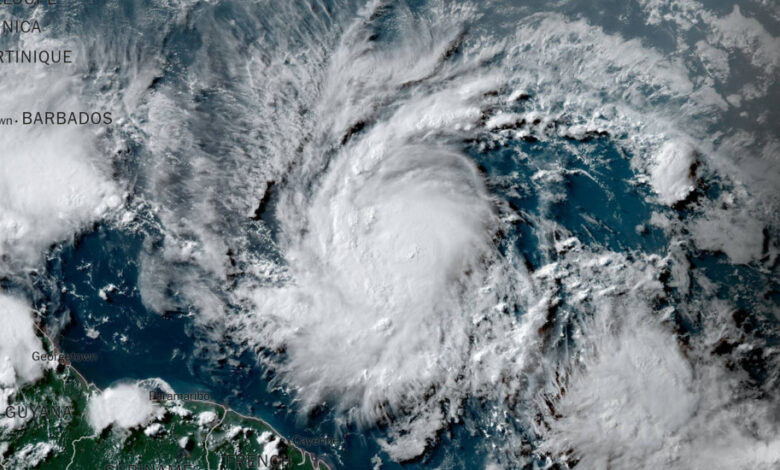
Beryl, now a hurricane, will ‘bring life-threatening winds,’ officials warn

Tropical Storm Beryl Hurricane Beryl was officially declared on Saturday afternoonwhich has strengthened since forming late Friday evening, reaching sustained wind speeds of 120 kilometers per hour, with higher gusts.
Hurricane Beryl, the first hurricane of the season, is expected to bring “life-threatening winds and storm surge” to the Windward Islands, southeast of Puerto Rico and north of Venezuela as it continues west, the National Hurricane Center said Saturday.
According to meteorologists, winds could be up to 30 percent stronger on the higher parts of the islands.
A hurricane warning was issued for Barbados, and several other Caribbean islands were under hurricane warnings, including St. Lucia, St. Vincent and the Grenadines, and Grenada. The islands of Martinique, Dominica, and Tobago were under tropical storm warnings.
A hurricane warning means that hurricane conditions are expected in the designated area within 36 hours and people should complete all preparations for the storm, including evacuations if local officials order them. hurricane watching indicates that hurricane conditions are possible within 48 hours and residents should prepare for action.
Meteorologists say Beryl is expected to hit Saint Vincent and the Grenadines on Monday, with damaging winds ahead of it expected to reach the capital, Kingstown, at 8:00 a.m. local time.
Some computer weather models suggest the storm could develop into a major hurricane of Category 3 or higher.
According to data from the National Oceanic and Atmospheric Administration, only three storms have reached Category 3 status this early in the season in the North Atlantic: Alma in 1966, Audrey in 1957 and an unnamed storm in 1916.
They all made landfall on the U.S. coast in the Gulf of Mexico: Alma near St. Marks, Florida; Audrey near Port Arthur, Texas; and the 1916 storm near Mobile, Alabama.
The system became Tropical Storm Beryl late Friday when sustained winds reached 39 miles per hour. At 74 miles per hour, a storm becomes a hurricane.
John Cangialosi, a meteorologist at the National Hurricane Center, wrote in an alert Friday that it is unusual for a storm to occur this far east in the Atlantic Ocean.
“There have been only a few storms in history that have formed so early in the year over the central or eastern tropical Atlantic,” he wrote.
Here are the most important things to know about the storm.
-
According to meteorologists, waves caused by Beryl are expected to reach the Windward Islands and southern Leeward Islands on Sunday evening, likely causing life-threatening surf and rip current conditions.
-
The storm is expected to move across the eastern Caribbean islands as early as Sunday evening, before crossing the central Caribbean Sea by midweek.
-
Five to six inches of rain, hurricane-force winds and dangerous storm surges are possible Sunday through Monday in the eastern Caribbean islands, including Barbados, and St. Vincent and the Grenadines.
-
There is considerable uncertainty in the forecast about the path the storm will take, especially after three days.
This hurricane season is expected to be busy.
Weather experts warn that the 2024 Atlantic hurricane season could be much more active than normal.
In late May, the National Oceanic and Atmospheric Administration predicted 17 to 25 named storms this year, an “above-normal” number and a prediction in line with more than a dozen forecasts earlier this year from experts at universities, private companies and government agencies.
During the hurricane season there are an average of 14 named storms.
The seasonal hurricane outlook was particularly aggressive because forecasters looking at the start of the season saw a combination of conditions not seen in records going back to the mid-19th century: record warm water temperatures in the Atlantic Ocean and the possible formation of the hurricane. weather pattern known as La Niña.
La Niña occurs in the Pacific Ocean as a result of changing ocean temperatures and affects weather worldwide.
When it is strong, it generally creates a calm environment in the Atlantic Ocean. This allows storms to develop more easily and grow stronger without being hampered by wind patterns that could otherwise prevent them from organizing.
John YoonAnd John Keefe contributed report.


