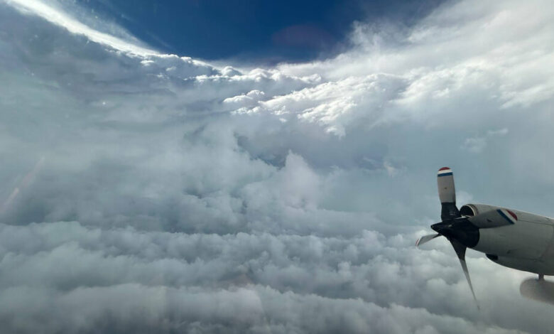
‘A rollercoaster in a car wash’: What it’s like to ride in Hurricane Beryl

Hurricane Beryl, which devastated islands in Grenada on Tuesday and is now headed toward Jamaica and the Cayman Islands, has broken records as the earliest hurricane on record to reach Category 4 and Category 5 intensity in the Atlantic basin. Winds of at least 160 miles per hour were registered on Monday.
“There are so many superlatives to describe Hurricane Beryl, given the time of year, the location and the strength,” said Jonathan Zawislak, meteorologist and flight director for the National Oceanic and Atmospheric Administration.
Dr. Zawislak is a hurricane hunter, the title held by about 30 to 40 scientists, data crunchers and pilots in Lakeland, Florida. They fly into hurricanes in three planes nicknamed Gonzo, Kermit and Miss Piggy. Both Kermit and Miss Piggy are equipped with Doppler radar on their bellies and tails, which scientists use to create 3-D images of the storm.
For the past three days, Dr. Zawislak and his team in Kermit have been sailing from St. Croix, U.S. Virgin Islands, and navigating the swirling eyewall of Hurricane Beryl. In a Category 4 or 5 storm like Beryl, the eyewall—the ring of thunderstorms, heavy rain and dangerous winds around the storm’s center—is loud and bumpy.
“It’s like being on a roller coaster in a car wash, except you don’t know when the ups and downs will happen, or what the next turn is,” Dr. Zawislak said Tuesday as he prepared for his third Beryl reconnaissance flight.
But the eye of the storm is calm. During daytime flights, Dr. Zawislak can look out of his bubble window behind the cockpit and see a calm bowl of clouds with a clear, blue sky above.
His job is to navigate through the chaos and find a route where Kermit can fly between 8,000 and 10,000 feet, maintaining an airspeed of exactly 210 knots. He must fly the plane directly into the wind so that it is not pushed back and forth.
Jonathan Shannon, spokesman for NOAA’s Aircraft Operations Center, said the purpose of these flights, especially for rapidly changing hurricanes, was to gather better data and thus be better prepared for emergencies.
Since Dr. Zawislak’s first flight on Sunday, Hurricane Beryl has undergone rapid intensification, meaning its wind speeds have increased by 35 miles per hour or more in a 24-hour period. Part of the change was due to an eyewall replacement cycle, or what Dr. Zawislak called the “ice skater effect”: the storm contracts like a figure skater pulling his arms in tight as he turns. By drawing energy from warm ocean water, the storm replaces the old eye with a new one and reorganizes the outer wall.
As the Earth’s atmosphere warms, more storms are experiencing this kind of rapid intensification. A recent study found that rapid intensification is now twice as likely for Atlantic hurricanes, at least in part because of human-caused climate change driven by the burning of fossil fuels.
Beryl is a disastrous start to what Hosmay Lopez, an oceanographer with NOAA’s Atlantic Oceanographic and Meteorological Laboratory, called the “most optimistic” forecast the agency has ever issued for an Atlantic hurricane season. NOAA is predicting a above normal hurricane season with four to seven major storms with wind speeds above 178 kilometers per hour.
The forecast is based on a shift in the El Niño-Southern Oscillation, a natural climate pattern associated with warmer conditions in the tropical Pacific Ocean, which is moving from a neutral state to La Niña. The calm conditions produced by La Niña, combined with abnormally warm ocean temperatures, increase the likelihood of Atlantic hurricanes forming.
As they travel, hurricanes stir up the ocean’s surface. They churn up colder water from deep beneath the surface, which can dilute the storm’s energy, like stirring a cup of coffee to cool it down. But along with exceptionally warm sea surface temperatures that have broken more than a year’s worth of records, temperatures are also higher than normal at greater depths.
“In this case, the coffee cup is very high, so it’s very difficult to mix cold water from below, even if there are strong winds,” Dr. Lopez said. Warmer temperatures at greater depths give the storm even more energy to pull out of the ocean, he said.
Hurricane season, which runs from June 1 to November 30, is historically quiet during June and July before picking up steam in August. Hurricane Beryl beat the previous record holder for the earliest Category 5 storm, Hurricane Emily in 2005, by about two weeks.


